“ISRO used its GSLV-F16 rocket to launch the NISAR satellite from Sriharikota on July 30, 2025. At a height of 743 kilometers, the rocket launched the satellite into a Sun-synchronous orbit. This was made possible by collaboration between NASA and ISRO. The launch was the first time dual-band radar was used on a mission to examine Earth in such detail. Now, the satellite continuously provides images while orbiting the earth every 12 days.”
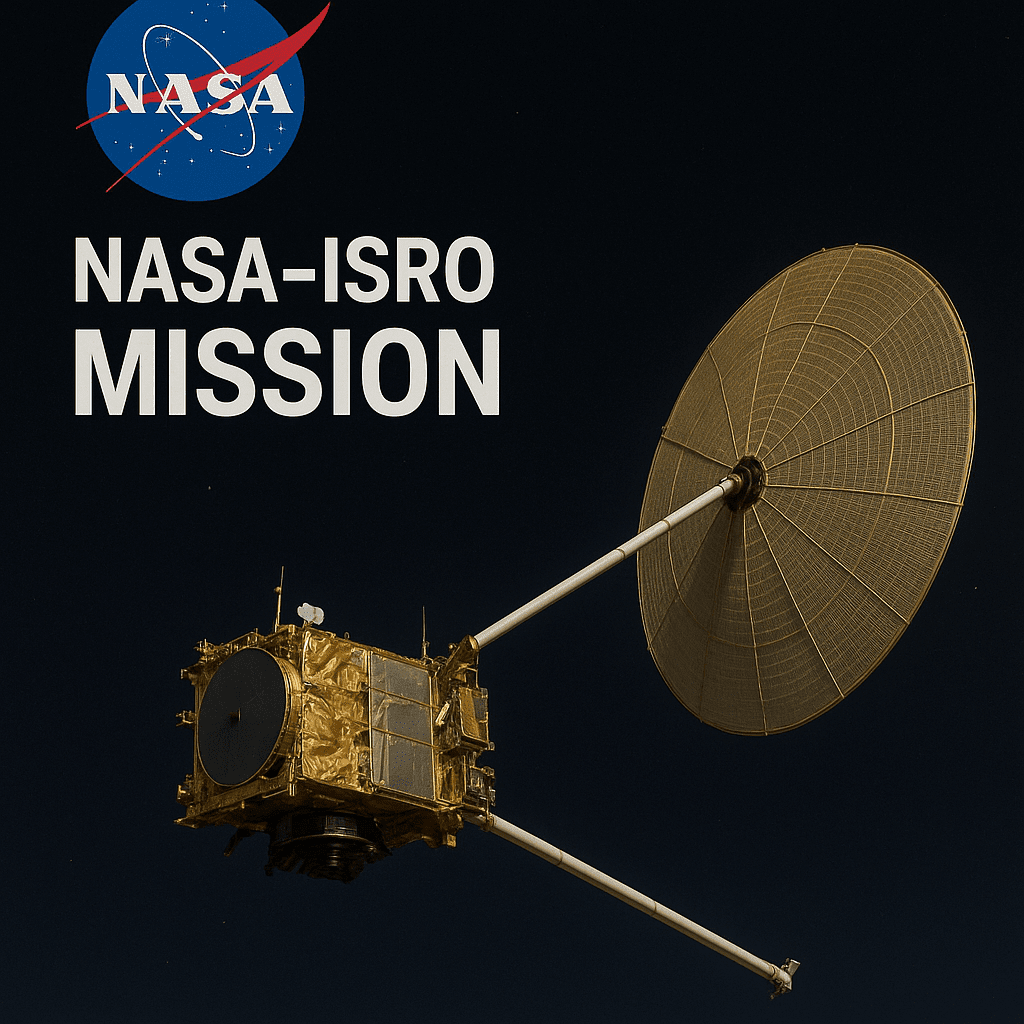
Design and Dual-Radar Framework
NISAR was constructed by NASA and ISRO engineers using two synthetic aperture radars:
- The L-band radar, which NASA provided, can penetrate thick ice and vegetation by using longer wavelengths (24 cm).
- The S-band radar, which ISRO supplied, has a high resolution for capturing details at the surface level.
A 12-meter deployable mesh reflector antenna was used to equip these radars. NISAR has a broad viewing area of 242 kilometers thanks to its architecture. Even the smallest changes in topography or glaciers, down to 1 centimeter, may be detected by it. This device was designed by engineers to scan a variety of environments, including mountains, cities, jungles, and seas.
Objectives of the Mission & Practical Uses in Reality
NISAR monitors how the Earth’s surface changes. Critical needs are supported by its radar data:
- It charts the movement of glaciers and the melting of ice sheets in the Himalayas and Arctic.
- By monitoring ground deformation, it assists specialists in predicting landslides and earthquakes.
- By determining flood plains and soil moisture, it aids in agricultural and water planning.
- NISAR offers near-real-time imagery during natural catastrophes like earthquakes and floods, which aids emergency teams in better preparation for responses.
NISAR is a potent instrument for science and policymaking since it was created by NASA and ISRO to provide governments and researchers with open access to its data.
Strategic Importance & Investment
For this mission, the United States and India contributed more than $1.3 billion. This collaborative endeavor demonstrates how space cooperation may advance global diplomacy and climate action.
NISAR is NASA’s most sophisticated radar satellite to date. Given the enormous scientific and humanitarian advantages, ISRO saw this as a high-priority mission. Both nations’ leaders referred to NISAR as a “life-saving satellite.” With no restrictions on data access, it continuously monitors Earth’s climate and catastrophic hazards.
From Creation to Implementation
In 2014, NASA and ISRO formed a collaboration agreement.
- ISRO constructed the S-band radar and satellite bus in India, while NASA created the L-band radar in California.
- NASA sent its radar equipment to ISRO’s satellite headquarters in Bengaluru in March 2024.
- The satellite’s temperature, vibration, and power performance were evaluated by engineers who combined the two radar systems.
- ISRO relocated the finished satellite to the Sriharikota launch site in June 2025.
The launch was delayed by a few technical issues, mostly involving the reflecting coatings on the antenna. Nevertheless, the teams overcame those obstacles and launched in July with success.
Timeline for Data Rollout and Commissioning
NISAR started its initial tasks immediately after liftoff.
- Within 20 minutes of entering orbit, it turned on.
- Signal confirmation was obtained by ISRO’s tracking stations and NASA’s Deep Space Network.
- Now, engineers calibrate the instruments and do system checks.
The duration of this commissioning phase is ninety days. NISAR will then start collecting data on a regular basis and share the results with researchers and organizations throughout the world.
Worldwide Effects & Climate Observation
NISAR addresses pressing global issues:
- Wildfires, glacier melting, and sea level rise are all consequences of climate change.
- Floods, landslides, and earthquakes occur often, destroying houses and taking thousands of lives.
Teams may now monitor these changes with NISAR before they become catastrophic. It watches, warns, and helps nations take prompt action, much like a satellite guardian. Its information will help with global initiatives such as:
- The Sustainable Development Goals of the United Nations
- The Climate Agreement in Paris
- Joint Earth scientific initiatives between NASA and ISRO
NISAR gives people who are making choices for the planet information that are transparent, trustworthy, and openly accessible by recording surface changes in real time.
“To comprehend the planet’s future, the globe needs facts, not just predictions. These information are provided by NISAR from 743 kilometers above the ground. It’s a satellite that watches Earth to safeguard it, not to conquer it.”